Why River Valleys Keep Turning Up in Regional Boundaries
River valleys can clarify regional boundaries by showing where people travelled, settled and met, while helping you distinguish a corridor from a true divide.
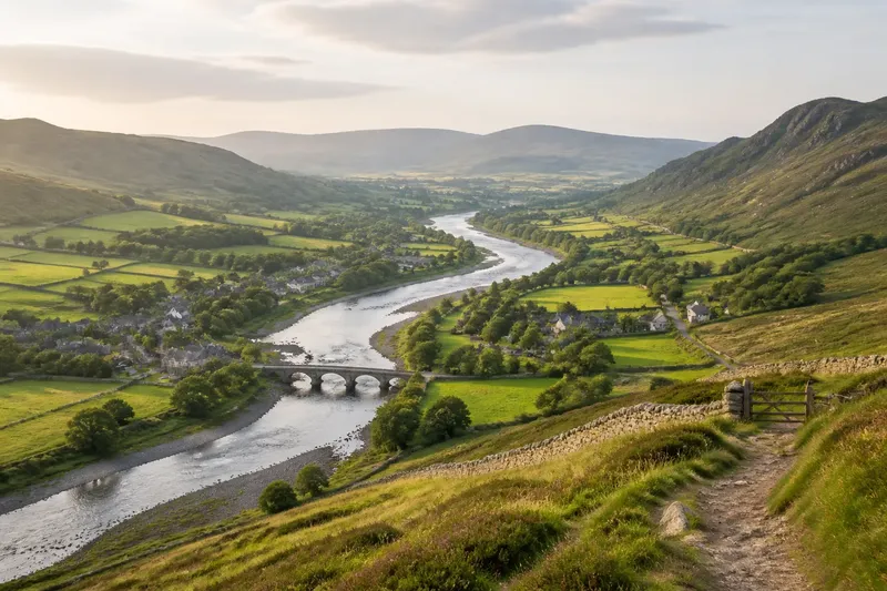
River valleys often clarify regional boundaries because they reveal where people could travel, settle and meet. To understand why river valleys keep turning up in regional boundaries, read the whole valley—not just the watercourse—as a route through the landscape, and ask whether it connected communities or separated them.
Read the valley as a route before treating it as a border
A river valley is more than a channel. It includes the river, its floodplain, adjoining slopes, tributary hollows and the passes or gaps that connect it to neighbouring country. Together, these features shape the cost and direction of movement.
A broad, gently graded valley may offer a relatively continuous route for walking, carts or later roads and railways. Settlements can cluster where the ground is workable, water is accessible and routes meet. The river can then become the spine of a connected region rather than its edge.
By contrast, a narrow gorge, marshy floodplain or steep-sided valley may restrict crossings and concentrate movement at a few bridges, fords or passes. Even then, the river itself does not automatically mark the boundary: people may use the same crossing points to maintain links on both banks.
Start with the shape of the land and the locations of routes. A line on a map tells you where a boundary has been drawn; the valley helps explain why that line may have mattered.
Choose the reading that fits what you are trying to explain
There is no single valley pattern behind every regional boundary. Sort the evidence by the question you have, because a route, a settlement corridor and a barrier leave different clues.
- If you are explaining a chain of towns or shared services, treat the valley first as a corridor. Look for settlements along the river or its terraces, roads following the valley floor, and tributary routes bringing people in from side valleys. This reading fits when daily movement appears to run lengthwise through the valley.
- If you are explaining a sharp change between neighbouring districts, examine the valley as a possible threshold. A steep slope, broad wet ground or scarcity of crossings may have made movement between banks less convenient than travel along the valley. This fits best when a boundary follows a difficult crossing zone, not merely because a river is visible.
- If the regional identity appears on both banks, read the river as a shared resource and meeting place. Markets, bridges, ferry points, work sites or recurring routes may draw both sides together. This is a better fit than a dividing-line explanation when connections cross the channel repeatedly.
- If the boundary changes direction around a tributary or pass, look for a network of routes. The main river may be only one part of a system linking uplands, side valleys and a larger settlement. This reading suits boundaries that follow several landforms rather than one neat line.
- If the map shows a river boundary but local connections seem to cross it, separate administrative edges from lived regions. A district line can serve governance while markets, speech, work or family ties continue across it. This fits when the formal map and everyday geography tell different stories.
Say you are comparing two neighbouring market towns, one on each bank. Imagine that both sit beside an old crossing and their roads converge there, while the official boundary follows the river; the observable pattern would support a shared valley connection, even though the map presents a dividing line.
Use settlement and crossing clues to test the corridor reading
Settlements show where a route could support repeated activity. Look for a sequence of villages along a valley floor or its slightly raised edges, where buildings avoid the most flood-prone ground but remain close to water and transport. A cluster at a tributary junction can indicate a meeting point between routes.
Crossings add a different kind of evidence. Bridges, fords and ferry sites reveal places where movement could pass from one bank to the other; roads converging on them suggest that the river linked local journeys as well as guiding them lengthwise. A single crossing may matter greatly, but it does not by itself prove a shared regional identity.
Compare these clues with the surrounding terrain. If a road leaves the valley through a low pass and joins another settlement network, the valley may belong to a broader route system. If steep uplands hem it in and crossings are scarce, the same valley might instead have channelled movement into a narrow strip.
For a first map reading, trace the main river, then mark tributary mouths, crossings, settlements and routes climbing out of the valley. The pattern is more informative than the river line alone.
Distinguish a natural corridor from a political boundary
A regional boundary is a human arrangement, even when it follows a conspicuous physical feature. Administrators may use a river because it is easy to recognise, because a crossing marks a practical control point, or because the channel already separates jurisdictions. Those choices do not erase older routes or shared habits.
Keep three questions apart: where people could travel, where they tended to meet, and where authorities drew a line. A valley can answer the first two without matching the third. A border may shift while the route through the valley remains useful, or a road may make a once-difficult crossing routine.
When local evidence is available, compare the map with everyday connections: where people shop, attend services, work or gather. Such patterns can reveal a regional tie that a boundary map obscures, but they should be treated as clues rather than as a substitute for local knowledge.
Which valley clues matter for your question?
Does a river usually divide a region?
No. A river can separate places where crossing is difficult, but it can also guide travel and bring settlements together. Look at the valley’s crossings, routes and settlement pattern before deciding which role fits.
Why do towns often follow a valley?
Valleys can provide access to water, workable ground and a relatively direct route through otherwise difficult terrain. Towns may also form where tributaries, bridges or roads meet, making the valley a centre of movement rather than simply a low strip of land.
What should I check on a map first?
Trace the river alongside its tributaries, crossings, roads, settlements and the slopes enclosing the valley. Then compare those features with the boundary, asking whether it follows a barrier, a route or an administrative line.
Can a valley connect places on both sides of a boundary?
Yes. A bridge, market route or shared transport corridor can connect communities even when a formal boundary follows the river. The strongest reading comes from considering those connections alongside the physical difficulty of crossing.
Keep the landscape and the lived region in view
A river valley is useful evidence because it makes movement easier to picture: routes follow its length, tributaries draw in side journeys and crossings concentrate contact. Its shape can help explain why settlements cluster and why a boundary might follow the water, but it cannot tell the whole story alone.
For a sound regional reading, match the map’s line to the valley’s actual form and to the connections people maintain across it. The most useful clue may be not the river at all, but the road, pass or crossing that shows how the landscape was used.